NEWS RELEASE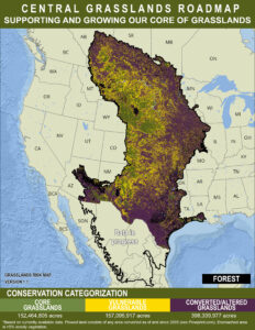
December 6,2022 – For Immediate Release
Contact: Tammy VerCauteren, Executive Director
Central Grasslands Assessment Map: A new tool to ensure the future of our grasslands.
FORT COLLINS, Colo. – The Central Grasslands Roadmap (CGR) is proud to introduce the Central Grasslands Assessment Map. Over the last three years a diverse community of more than 200 partners from Canada, the United States, Mexico, and Indigenous Nations have collaborated to inform and endorse this map to help improve the health of our grasslands from degraded and fragmented to thriving, productive lands for both people and wildlife. This important new map showcases our Central Grasslands and is guiding voluntary investments in their conservation.
The Central Grasslands span more than 700 million acres across Indigenous Nations, Canada, the United States, and Mexico. Unfortunately, much of this landscape has been fragmented through conversion to row-crop agriculture and the spread of invasive trees and shrubs.
As grasslands disappear, so do many of the benefits they provide—and more than 50 million acres of grassland have been lost in the last 10 years. Many people are unaware of the benefits that grasslands provide or the implications of their declines and what it means to current and future generations. For example, between 1990 and 2019, landowners in the Western United States lost out on nearly $5 billion worth of forage because of the growth of new trees. The amount of forage lost over those three decades equates to 332 million tons, or enough hay bales to circle the globe 22 times.
These are just a few of the factors that are harming the vital ecological functions that grasslands provide including healthy air, clean water, and cultural and recreational benefits. Fortunately, it isn’t too late to improve the health of our grasslands back to thriving, productive lands for both people and wildlife.
“The Great Plains is home to some of the last remaining large and intact grasslands in the world, but this biome is the most imperiled and least protected of the world’s major vegetation types,” said Dr. Dirac Twidwell, rangeland ecologist at the University of Nebraska–Lincoln and science adviser to the USDA Natural Resources Conservation Service and its Working Lands for Wildlife program. “The Central Grasslands Assessment Map represents an unprecedented collaborative effort to combine the latest science and technology for more strategic conservation action and to conserve the culture, ecosystem services, and unique biodiversity that depend on grasslands.”
To address these challenges, the CGR provides a flexible strategic framework. This assessment map is core to implementing this framework. Partners and community members can use it to identify opportunities where short- and long-term conservation programs need to take place. This large-scale approach works best when partners work together by combining local priorities, resource concerns, and community will.
This map categorizes three areas of conservation to support and grow our core grasslands. By keeping the grass intact and “green-side up”, (shown in green on the map) these grassland areas can ensure food security, traditional cultural values and land sovereignty for Indigenous Nations. Voluntary short- and long-term conservation programs and practices are needed to keep these core grasslands intact and support grass-based economies to help rural communities thrive.
Areas marked in yellow represent lands impacted by the spread of invasive woody vegetation and other annual species that negatively change the characteristic of these grasslands, and by areas under immediate threat of conversion to row-crop agriculture. Every effort should be made to ensure that these areas remain healthy, connected grasslands that benefit both rural communities and wildlife.
Purple indicates areas that need strategic investment that include, but are not limited to, removing invasive woody species, converting cropland on marginal soils back to grassland, and connecting to larger blocks of existing grassland.
To learn more about the map, explore data layers, and how you can help to support the health of this irreplaceable landscape visit www.grasslandsroadmap.org
About the Central Grasslands Roadmap
The Central Grasslands Roadmap aims to guide and inform innovative and connected conservation for the benefit of grassland birds, pollinators and mammals, as well as to ensure viable human communities across the landscape of one of North America’s most biogeographically unique areas. The Roadmap community includes a cross-section of leaders and experts that live and work in the Central Grasslands — including producers on working land, Indigenous Nations, federal, state and provincial agencies, foundations, industry, and nongovernmental organizations including; land trusts, conservation organizations, and academia. For more information: https://www.grasslandsroadmap.org/
About Bird Conservancy of the Rockies
Bird Conservancy of the Rockies is a Colorado-based nonprofit that works to conserve birds and their habitats through an integrated approach of science, education and land stewardship. Our work extends from the Rockies to the Great Plains, Mexico and beyond. Together, we are improving native bird populations, the land and the lives of people. We envision a world where birds are forever abundant, contributing to healthy landscapes and inspiring human curiosity and love of nature. For more information: https://www.birdconservancy.org/